File:land-usage1.png

Size of this preview: 800 × 400 pixels. Other resolution: 1,600 × 800 pixels.
Original file (1,600 × 800 pixels, file size: 356 KB, MIME type: image/png)
Summary
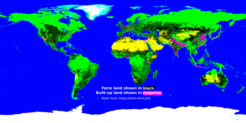
Black is farm land. Magenta is built-up land (housing etc) (which is hard to see except in China & India). The rest could perhaps be considered "untouched" natural land.
Methodology
Image generator code:
pop  << data/population.data-float64-8640x4320 # population counts
crop << data/cropland.data-float32-4320x2160   # cropland fraction of land
past << data/pasture.data-float32-4320x2160    # pasture fraction of land
earth<< data/blue-marble-posterized.png        # base layer

pop @@ quantity_to_density
pop :: earth.r
pop -= 400 # hard threshold (people per km^2) for land to be marked as 'built-up'
pop @@ 01
crop >= 0
crop @@ neg
crop :: earth.r
past >= 0
past @@ neg
past :: earth.r

earth.r *= crop
earth.r *= past
earth.r += pop
earth.r @@ 01
earth.g *= crop
earth.g *= past
earth.g -= pop
earth.g @@ 01
earth.b *= crop
earth.b *= past
earth.b += pop
earth.b @@ 01
earth >> data/land-usage1.png
Note: we are using population density as a best guess for determining which land is built-up. In theory that might not be perfectly accurate, but in practice, the end result is matches well enough with totals from other data sources.
See also
- File:land-crop1.png - crop land
- File:land-pasture1.png - pasture
- File:land-builtup1.png - built-up land
- File:land-wild1.png - untouched lands
File history
Click on a date/time to view the file as it appeared at that time.
| Date/Time | Thumbnail | Dimensions | User | Comment | |
|---|---|---|---|---|---|
| current | 09:35, 30 August 2022 | | 1,600 × 800 (356 KB) | Elie (talk | contribs) |
You cannot overwrite this file.
File usage
The following page uses this file: