File:population-earth1.png: Difference between revisions
m (Conversion script moved page File:Population-earth1.png to File:population-earth1.png: Converting page titles to lowercase) |
|||
| Line 4: | Line 4: | ||
Everything in black is population. | Everything in black is population. | ||
Note: Some border lines may be completely obscured by populations (especially India's borders with Bangladesh, Pakistan, and Bhutan). Still better than the opposite (letting the border lines obscure the populations). | '''Note:''' Some border lines may be completely obscured by populations (especially India's borders with Bangladesh, Pakistan, and Bhutan). Still better than the opposite (letting the border lines obscure the populations). | ||
'''Note:''' Be careful not to confuse small blue dots (lakes) for small black dots (population). In the next version I'll try to make the blue parts lighter (or erase small bodies of water) so this doesn't happen. | |||
<!-- | |||
TODO: try making another [[:File:blue-marble-posterized.png]] where i blur it before posterizing, so small lakes don't appear at all. be sure to check that most of the coastlines would still align with [[:File:borders-black-on-white.png]]. we'll see how it turns out | |||
TODO: also try just changing the image generator code to lighten the blue parts (<code>r *= 1.1</code> and <code>g *= 1.1</code> perhaps - and if forests and deserts look less distinguishable from each other, so be it). Note this might still not be good enough as some image downscaling algorithms aren't gamma-corrected, so dark-ish edges between blue and (green or yellow) may still be enough to look like population. we'll see. | |||
--> | |||
==Methodology== | ==Methodology== | ||
Revision as of 09:17, 25 February 2024
Summary
An isochromic map of the world population, superimposed on a pastel-color background that shows land, water, and borders.
Everything in black is population.
Note: Some border lines may be completely obscured by populations (especially India's borders with Bangladesh, Pakistan, and Bhutan). Still better than the opposite (letting the border lines obscure the populations).
Note: Be careful not to confuse small blue dots (lakes) for small black dots (population). In the next version I'll try to make the blue parts lighter (or erase small bodies of water) so this doesn't happen.
Methodology
Image generator code:
# load files
pop << data/population.data-float64-8640x4320
earth << data/blue-marble-posterized.png
borders << data/borders-black-on-white.png
borders @@ negative

# resize things to fit the 'earth' background
pop :: _earth.r # the '_' preserves the total population
borders :: earth.r
borders *= 6 # brighten the lines

# lighten the background
earth.r += 0.6
earth.g += 0.6
earth.b += 0.6

# show the borders in white
earth.r >= borders
earth.g >= borders
earth.b >= borders

# show the population in black
pop /= 800000 # max people per pixel
pop @@ spread
pop @@ negative
earth.r <= pop
earth.g <= pop
earth.b <= pop

# save
earth >> data/population-earth1.png
File history
Click on a date/time to view the file as it appeared at that time.
| Date/Time | Thumbnail | Dimensions | User | Comment | |
|---|---|---|---|---|---|
| current | 03:52, 7 August 2022 | 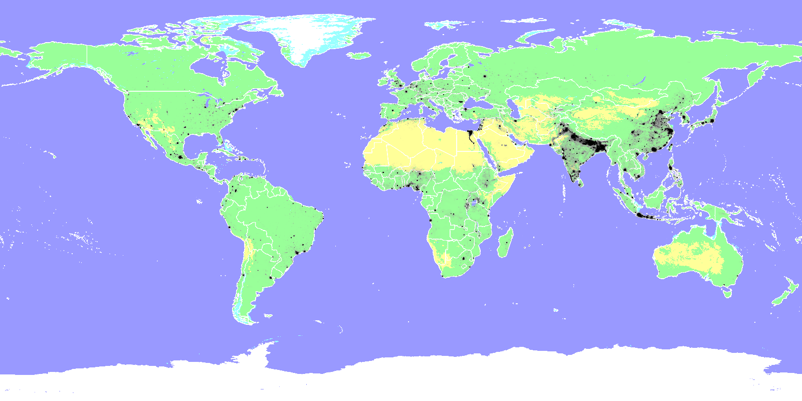 | 1,600 × 800 (371 KB) | Elie (talk | contribs) | An Term:isochromic map of the world population, superimposed on a pastel-color background that shows land, water, and borders. Everything in black is population. Note: Some border lines may be completely obscured by populations (especially India's borders with Bangladesh, Pakistan, and Bhutan). Still better than the opposite (letting the border lines obscure the populations). |
You cannot overwrite this file.
File usage
The following 2 pages use this file:
- Wind power/Geography
- File:Population-earth1.png (file redirect)